At a Glance
- Two areas are being monitored for development in the Atlantic Basin.
- One area is likely to develop into a tropical depression or storm in the next few days in the Caribbean Sea.
- That could pose a threat to parts of the Caribbean and Central America.
- A second area in the Bermuda Triangle is looking less likely for development.
- That second area won't threaten the U.S.
Sign up for the Morning Brief email newsletter to get weekday updates from The Weather Channel and our meteorologists.
Two areas are being monitored for development, one in the Caribbean Sea that could impact Central America, the other in the Atlantic Ocean that, while not a direct U.S. threat, will have some indirect impacts along the East Coast into the weekend.
We still have about a month left of the 2022 Atlantic hurricane season. According to the National Hurricane Center, a typical hurricane season usually produces one more storm before the season ends. The next storm in the Atlantic Basin would earn the name "Lisa," the 12th name in this season's list.
(MORE: When The Last Storm Of Hurricane Season Typically Happens)
Right on cue, we have a couple of areas of interest, shown by the circles in the graphic below.

Caribbean Concern
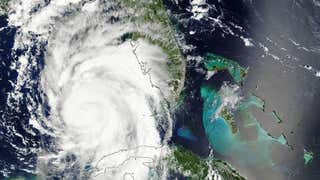
A broad area of low pressure has formed over the eastern Caribbean Sea, and is now likely to develop into a tropical depression or storm by early week, according to the National Hurricane Center. The disorganized system has been tagged as Invest 95L by the NHC to free up resources to investigate the system, including the Hurricane Hunters, which flew into the system Saturday afternoon.
Multiple computer forecast models have repeatedly shown a westward track through the Caribbean over the past several days.
Assuming a tropical depression or storm forms, it should continue migrating west or west-northwest in the Caribbean Sea, steered by an expansive dome of high pressure to its north.

It's too soon to determine exactly where it will track.
For now the most likely track would be toward some part of Central America mid to late week.
However, interests in Hispaniola, Jamaica, the Cayman Islands and Mexico's Yucatan Peninsula should also monitor this forecast closely, as a more northern track isn't out of the question in the week ahead.
As to how strong it may become, there are mixed signals.
On one hand, per usual, there is plenty of deep, warm water in the Caribbean Sea for a tropical system to feed off.
However, there is plenty of dry air over the western half of the Caribbean Sea, right now, and, some forecast models suggest if the system moves a bit too far north in the Caribbean Sea it may face increased wind shear. Both of these factors are typically nemeses of tropical systems.

Regardless of all this, there's a potential for locally heavy rain over the next several days from the Virgin Islands, Puerto Rico, Hispaniola and eventually Jamaica. This could trigger dangerous flash flooding and landslides, in areas of hilly or mountainous terrain.
So, check back with us for updates to this forecast in the coming days.
East Coast Wave Generator
The second system we're watching isn't a U.S. threat, but will contribute to a pattern that will be an East Coast nuisance.
A swirl of low pressure may form soon in the Bermuda Triangle, between Bermuda and Puerto Rico and well east of the Bahamas.
Regardless of what meteorologists call that low, it will sit in place or meander near or west of Bermuda before weakening later in the weekend.
It will team up with high pressure over the Northeast U.S. to produce persistent winds along much of the Eastern Seaboard at least this weekend.
Aside from a windy weekend, that persistent onshore wind flow will also build high surf along the coast, leading to at least some modest coastal flooding at high tide, along with rip currents.
Charleston saw some higher than usual tides on Saturday.
If you're headed to an Atlantic beach this weekend and it's warm enough to tempt you to go into the water, it's probably best to stay out of the water due to the threat of rip currents.

The Weather Company’s primary journalistic mission is to report on breaking weather news, the environment and the importance of science to our lives. This story does not necessarily represent the position of our parent company, IBM.


