At a Glance
- Parts of western and upstate New York picked up feet of snow.
- This event may have set an all-time state 24-hour snowfall record.
- Western New York was also clobbered by a similar storm in November 2014.
Sign up for the Morning Brief email newsletter to get weekday updates from The Weather Channel and our meteorologists.
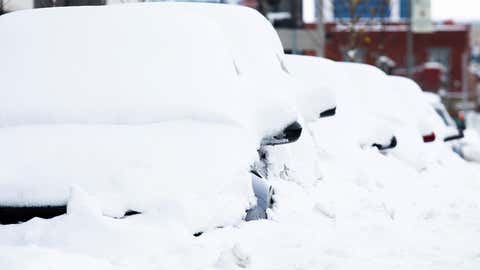
A historic lake-effect snowstorm dumped feet of snow in parts of western and upstate New York, and may have set a new all-time state record.
The event kicked off in the eastern Great Lakes on Wednesday, November 16, with bands of snow off Lake Erie well south of Buffalo into western New York's southern tier, northwest Pennsylvania and northeast Ohio, as well as a band off Lake Ontario into Oswego, north of Syracuse, New York.
But this snowstorm shifted into high gear beginning late Thursday, November 17, continuing into Friday night, when winds shifted to a southwesterly direction, aligning with the length of lakes Erie and Ontario, generating nearly stationary bands over each lake with intense snowfall.
Winds shifted the Lake Erie band north into downtown Buffalo and the city's northern suburbs later Friday night into Saturday, before the band swept back through the entire metro area one last time late Saturday night.
The most prolific snowfall was, as usual, in the southern suburbs of Buffalo known locally as the "Southtowns".
One observer near Hamburg, about 15 miles south of downtown Buffalo, reported 81 inches of snowfall from Nov. 16-20, according to the National Weather Service. The weight of the heavy snow lead to a partial roof collapse of a Hamburg bowling alley.
Eighty inches of snow was reported in Orchard Park, near the location of Highmark Stadium, home of the National Football League's Buffalo Bills.
Other totals of five feet or more from Erie County, New York, included Blasdell (76 inches) and Elma (61.7 inches).
Other totals of five feet or more from Erie County, New York, included Blasdell (76 inches) and Elma (61.7 inches).
Since the band shifted north, then sagged back south, even parts of the Buffalo metro that aren't nearly as snowy as the Southtowns picked up heavy accumulations.
From 12 to 20 inches of snow piled up in Niagara County, including Niagara Falls.
And Buffalo-Niagara International Airport, northeast of downtown, tallied 36.6 inches of snow, just over a third of their average yearly snowfall (95.4 inches) in just three days.
Impressive snow totals also came in from the Lake Ontario snowbelts.
Watertown, New York, about 25 miles south of the Canadian border along Interstate 81 reported up to 62 inches of snowfall.
Dozens of motorists were stranded on snow-choked roads, despite the travel ban. Some semi trucks looking for an alternate route to the shutdown New York State Thruway (Interstate 90) became stuck on side roads, blocking routes for first responders.
State Snowfall Record?
Snowfall rates were up to 4 to 5 inches per hour in the Buffalo metro as the band parked, then shifted, accompanied by occasional lightning strikes for hours.
With rates that impressive, it's possible this snowstorm may have been a state record-breaker.
Officially, the heaviest 24-hour snowfall in New York state was a 50-inch snowfall on Feb. 1, 1966 in Camden, about 30 miles northeast of Syracuse in the Lake Ontario snowbelt, according to NOAA's National Centers For Environmental Information (NCEI), which maintains state records for snowfall, among other weather variables.
However, weather historians Christopher Burt and David Ludlum have documented heavier 24-hour snowfalls in the Empire State.
These include a 68-inch snowfall in Adams on Jan. 9, 1976 and a 77-inch event in Montague Township From Jan. 11-12, 1997. Burt noted in his book "Extreme Weather" the Montague Township measurement was not considered official, because, snowfall measurements were made too frequently during the storm, which may have inflated the total. To standardize as much as possible, the National Weather Service established a guideline of taking snowfall measurements every six hours.
As of the time this article was updated, the NWS office in Buffalo was closely examining all snowfall totals recorded during this event. NWS-Buffalo said they will also work with the New York State Climatologist, the Northeast Regional Climate Center, NWS Eastern Region headquarters and the NCEI to determine if any county or statewide snowfall records were set, making sure the data was reliable and standard measurement techniques were used.
So, we may not know for some time whether a record was officially shattered.
The extreme nature of this event was due in part to what had been one of the warmest starts to November on record in the Great Lakes, pushing lake water temperatures to among the warmest on record for mid-November in the past 27 years.
Surreal Sights
First there was the sight of the wall of snow lit up at night by both city lights and occasional lightning as it pushed into downtown Buffalo.
Then the whiteout conditions in the heart of the lake-effect snowband. Yes, literally, a whiteout. This is why travel bans were instituted on affected parts of the New York State Thruway (Interstate 90) prior to the storm.
Then there was digging out, requiring backhoes instead of shovels and regular-sized snowthrowers.
Even the NFL's Buffalo Bills needed some help getting out of their homes to the airport to fly to Detroit, where their game on Nov. 20 was moved due to the storm.
Recent November Deja Vu
Eight years ago, Buffalo and western New York were also hammered by a prolific, multi-day, lake-effect snowstorm.
Up to 88 inches of snow buried the Buffalo Southtowns, a record for the region.
A 132-mile long section of the New York State Thruway (Interstate 90) was shut down for several days.
"There were 14 fatalities with this storm, hundreds of major roof collapses and structural failures, thousands of stranded motorists and scattered food and gas shortages due to impassable roads," the National Weather Service in Buffalo wrote in a post-storm summary.
In 2000, two feet of snow in the days leading up to Thanksgiving trapped thousands on roads, in schools or businesses in what was considered the most disruptive storm in the Buffalo metro since the infamous Blizzard of 1977, according to the National Weather Service.

The Weather Company’s primary journalistic mission is to report on breaking weather news, the environment and the importance of science to our lives. This story does not necessarily represent the position of our parent company, IBM.