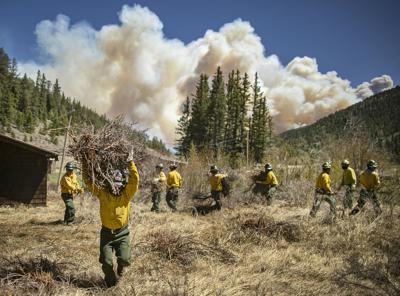
Firefighters with Structure Group 4 clear brush and debris away from cabins along Highway 518 near the Taos County line in June while fire rages over the nearby ridge. Officials say the Hermits Peak/Calf Canyon Fire is 96 percent contained and may be fully contained.
Firefighters with Structure Group 4 clear brush and debris away from cabins along Highway 518 near the Taos County line in June while fire rages over the nearby ridge. Officials say the Hermits Peak/Calf Canyon Fire is 96 percent contained and may be fully contained.
The most devastating fire in New Mexico history is nearly at its conclusion, a disaster declaration has been extended for another month and fire restrictions were lifted in many areas of the state Monday.
The biggest news emerging from the Hermits Peak/Calf Canyon Fire was the Federal Emergency Management Agency’s decision to extend a disaster declaration as floods ravage the burn scar from the blaze in Northern New Mexico.
The presidential disaster declaration, instituted in May, will now be in effect until Sept. 6, according to a news release issued Monday by Gov. Michelle Lujan Grisham.
Lujan Grisham had asked President Joe Biden to direct FEMA to extend the disaster declaration beyond its original 90 days as the effects of the 341,735-acre blaze grew during near-incessant rainstorms in Mora and San Miguel counties. The declaration will now be in effect through Sept. 6.
The governor also has asked FEMA continue to cover 100 percent of total eligible costs under the extended declaration, though that request has not yet been granted, according to the news release.
Meanwhile, the National Forest Service announced Monday the fire is now 96 percent contained, though a spokeswoman for the incident management team working the fire said heavy rains in the remote region where the blaze is located may have put it out.
Spokeswoman Carrie Templin said the last area to be contained is located in the Monte Aplanado region of Mora County. She noted heavy rains have made it unsafe for fire crews to reach the area on foot and officials will not announce total containment until they can get people into the area to verify.
She said fire officials will not draw a black line on the fire map — which denotes containment — until crews can be on site.
“We haven’t seen it on the ground for ourselves,” she said, adding there is no timetable for when Southwest Area Incident Management Team 5 will be able to hike into the region and verify the fire’s containment.
While helicopters and satellite images could help with containment verification, Templin said it is necessary to take “that extra step” and check on the ground.
“[Images via satellite or helicopter] may not be the same things you see when you walk in on the ground and actually look, and touch,” she said.
Ground crews are focused on mitigating further damage in the burn scar area brought on by monsoons, Templin added.
The rains did allow state fire restriction to be lifted Monday. In a news release, the state’s Energy, Minerals and Natural Resources Department’s Forestry Division announced it is rescinding an April 22 order prohibiting smoking, fireworks, campfires and open fires on land that is not overseen by municipal, tribal or federal agencies.


