
DENVER — Flash flooding threatened communities across the Front Range Monday. Here are the latest updates.
8:45 p.m.
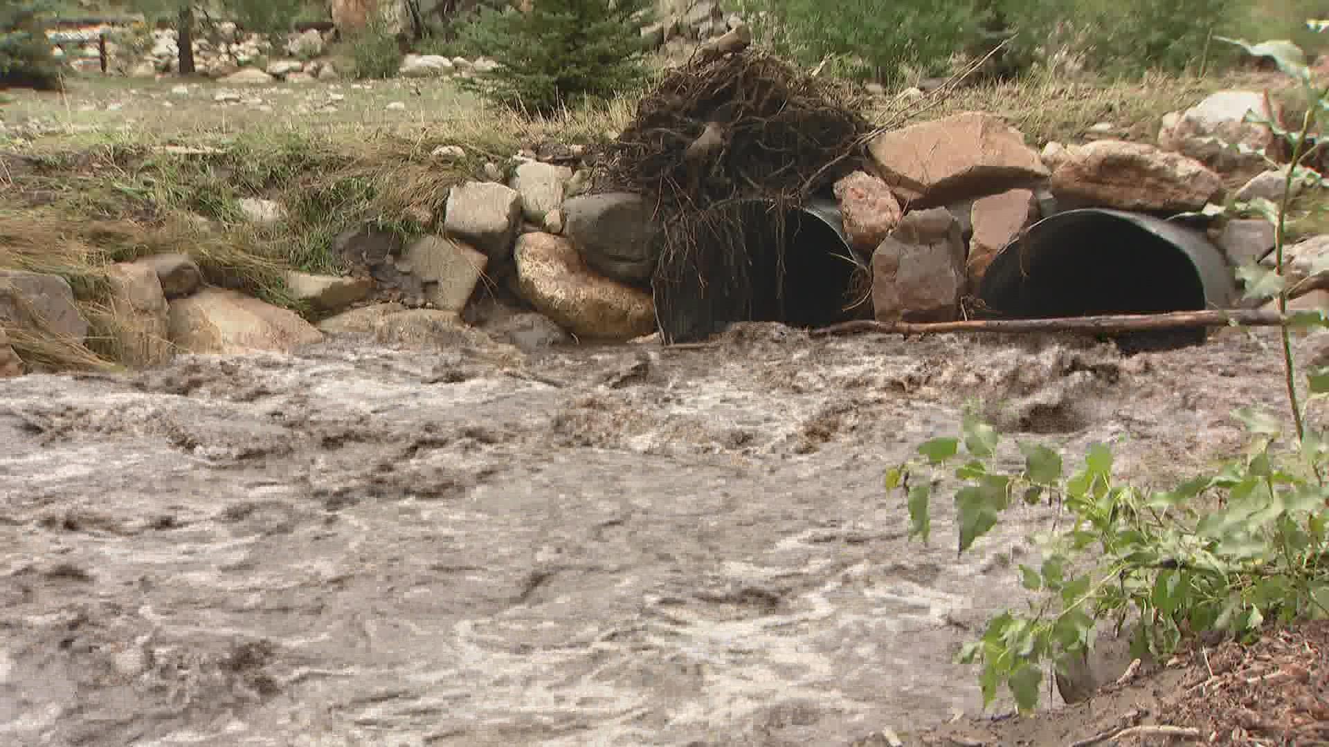
Communities around Drake and Glen Haven in Larimer County reported destructive flooding flowing down from the Cameron Peak Fire burn scar.
The fire burned less than a mile from the communities surrounding the town of Glen Haven. Two years later, the river is still black, flooding every time it rains.
"This is the eighth time this summer," said Jim Morton, who lives just outside Glen Haven. "Prior to the fire it wasn’t an issue, but that burn scar just won’t hold the water."
The front of Morton's property was completely covered in silt and ash that flowed down from the burn scar, flooding outside the banks of the river. Large boulders were tossed around the area, showing the power of the water.
So far this year, the National Weather Service has issued 31 flash flood warnings for the Glen Haven area, including 10 this month alone. In 2020 before the Cameron Peak Fire, there was one flash flood warning all year. The year before, there were none.
"You kind of wonder, how long is it going to take to revegetate? I guess that’s going to be what’s going to be required," Morton said. "We’ve gotten used to it, because this is about the eighth time this summer that it’s happened, although today was the worst."
8:35 p.m.
Interstate 70 has reopened in both directions between Glenwood Springs and Dotsero after being closed due to a flash flood warning.
5:18 p.m.
The Colorado Department of Transportation said Interstate 70 is closed in both directions from Glenwood Springs to Dotsero due to a flash flood warning. That warning is in effect until 8 p.m. The closure will remain in place until the warning is lifted and the roadway is inspected.
CDOT automatically closes the flood-prone stretch of highway anytime a Flash Flood Warning is issued by the National Weather Service.
The Grizzly Creek burn scar is located right near the highway, and burn scars are especially vulnerable to flash flooding due to the lack of vegetation to absorb moisture. As a result, flood-driven mudslides are common near or even over the interstate.
5 p.m.
The area with the most rainfall so far: Confluence Park in Aurora, with 2.44 inches:
4:30 p.m.
The Elbert County Office of Emergency Management reported flooding in multiple areas of County Road 17/21 between CR 124 and CR 114. The office also said that CR 106 west of the canyon was flooded.
The Larimer County Sheriff's Office said Highway 34 between Loveland and Estes Park, and also County Road 43, were back open.
4:20 p.m.
Tonight's showing of "Dune" at Film on the Rocks at Red Rocks Park & Amphitheatre was postponed to Sept. 26 due to inclement weather.
The Aurora Police Department said street flooding in the areas of South Parker Road and East Quincy Avenue, and East Dartmouth Avenue and South Chambers Road was making roads impassible.
Aurora had multiple accidents due to rain and flooding.
9NEWS meteorologist Cory Reppenhagen has been driving around the Denver metro area and has some street flooding reports:
4:10 p.m.
The worst of the rain is starting to trudge out of the DTC, Centennial, Lone Tree, Highlands Ranch, and Castle Rock areas.
We've already seen as much as 2 inches of rain in just 30 minutes in some cases, leading to reports of street flooding across parts of the south metro area.
There's still some flood risk over the next two to three hours for the Denver area, but the overall risk is lower than it was a few hours ago. In other words, for most areas, the worst is over and done with.
Also, the Centennial Airport recorded a 62 mph wind gust with a severe-warned thunderstorm around 3:30 p.m.
-Meteorologist Chris Bianchi
4 p.m.
As of 3:55 p.m., Denver International Airport (DIA) said it was on a ground stop due to thunderstorms in the area. Passengers should check with their airline for most recent flight status.
3:50 p.m.
A new Flash Flood Warning was issued until 6:45 p.m. for parts of Arapahoe and Douglas counties including Centennial, Parker and Foxfield.
There's also a new Severe Thunderstorm Warning for parts of Adams and Arapahoe counties including Strasburg, Bennett and Watkins until 4:30 p.m. The warning skirts just southeast of Denver International Airport.
Lone Tree said on Twitter that there's street flooding in spots throughout the city, including on Park Meadows Drive between South Yosemite Street and Acres Green Drive.
The Denver Tech Center has seen 1.34 inches of rain in an hour.
3:40 p.m.
A 9NEWS viewer shared this photo from Castle Rock:

3:20 p.m.
A Flash Flood Warning has been issued through 6:15 p.m. for an area south of the metro area including Lone Tree, Castle Pines, Sedalia and Louviers.
Rainfall rates between 1-2" in 15 minutes were forecast.
Sedalia reported 1.9 inches of rain as of 3 p.m., according to the National Weather Service.
A Severe Thunderstorm Warning was issued through 4:15 p.m. for Centennial, Castle Rock and Parker.
3:15 p.m.
Highway 34 was closed between County Road 29 in Loveland and Mall Road in Estes Park due to flooding conditions.
A Flash Flood Warning is in effect until 5:30 p.m. for an area of Larimer County that includes Glen Haven and Drake.
Dangerous flooding was occurring in the area of Glen Haven, including on County Road 43. Rainfall rates of 2.5 inches per hour were being observed in Drake, according to National Weather Service (NWS) Boulder.
There are also strong thunderstorms over Elbert and Douglas counties with flooding likely and hail locally up to 3/4 inch in diameter.
A Flood Watch is in effect Monday along the mountains of Colorado as well as Colorado Springs.
More specifically, we're really looking at the Front Range, Park County and the Palmer Divide. This includes Cameron Peak and Calwood burn scars.
Some areas could get rainfall rates up to two inches in less than an hour, and significant flash flooding is possible in the burn areas. Models have been trending more towards a threat in the Denver area, even if it is not included in the Flash Flood watch.
SUGGESTED VIDEOS: Science is Cool