At a Glance
- Oregon's Bootleg Fire has consumed more than 330 square miles.
- A blaze in Washington burned homes on tribal lands.
- Heat and drought have created extreme fire conditions.
Blazing wildfires have burned through more than a million acres of land in a dozen states, destroying houses, forcing people from their homes and threatening tribal lands in their path.
That equals about 1,500 square miles. About one third of that was burning in Oregon and Washington Wednesday, prompting the U.S. Forest Service Northwest to put the region at Preparedness Level 5, the highest category of wildfire activity.
"This is quite early in the fire season to reach that level," the Forest Service tweeted.
More than 16,650 firefighters and support personnel were battling 68 large wildfires in 12 states Wednesday, according to the National Interagency Fire Center.
Nearly all are in the western half of the country, where vegetation baked by record heat in some areas and historic drought across the region have created conditions ripe for dangerous wildfires.
(MORE: Jet Fuel Shortage Could Affect Firefighting Efforts)
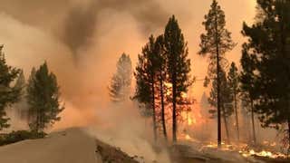
The largest fire burning in the nation is the Bootleg Fire, which has consumed more than 330 square miles near Klamath Falls in southeast Oregon.
“We’re making steady progress where winds and terrain allow,” incident commander Rob Allen said in an update Wednesday morning. “But for the third day in a row, firefighters had to disengage at times for their safety and weather isn’t going to change for the foreseeable future.”
Evacuations remained in place in Lake and Klamath counties. Numerous homes and structures have already been burned by the fire, which started on July 6. More than 1,900 structures remain threatened.
Fire officials said the blaze was exhibiting extreme fire behavior, is driven by "drought-affected fuels."
Be Prepared With This Safety Gear (SPONSORED)
About 86% of the Pacific Northwest is in drought, according to latest weekly update from NOAA's National Integrated Drought Information System. About 32% of the region is experiencing extreme or exceptional drought conditions, the two highest categories.
Overall, drought conditions cover 47% of the area in the Lower 48 states, nearly all in the West.
(MORE: Virtually the Entire West Could Be in Drought This Summer, NOAA Says)
The relentless weather isn't expected to let up any time soon.
"In the interior Northwest and northern Rockies, there's little good news in the forecast," weather.com senior meteorologist Jonathan Erdman said. "Though not as record-busting as last month, another heat wave is forecast to build into the area, as well as parts of southwestern Canada, into the weekend. As a result, there's also little to no rain in sight."
Dry conditions are expected to continue in California, and while Arizona will see daily scattered thunderstorms, rain over fire-scarred areas could trigger dangerous debris flows, Erdman said.
In the long-term, scientists say climate change fueled by greenhouse gas emissions will continue to drive heat and drought, and lead to an increased risk of wildfires in parts of the U.S.
Here's a state-by-state look at some of the other major wildfires burning in the western U.S. as of Wednesday afternoon.
Oregon
In addition to the Bootleg Fire, at least five other large blazes are burning across the state.
The Lick Creek Fire has consumed more than 98 square miles in the Umatilla National Forest just south of the Washington state line.
The fire was one of several ignited by lightning strikes on July 7, according to the U.S. Forest Service. It was 20% contained, and evacuation orders remained in effect in Asotin and Garfield Counties.
Evacuation notices were also issued in central Oregon's Jefferson and Deschutes counties, where the Grandview Fire has burned more than 9 square miles. Officials said the fire was 10% contained.
"There are still homes and other structures at risk, but fortunately the fire lines that crews created around the south-eastern perimeter have proven to be very successful," a Wednesday morning update said.
Washington
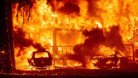
The Confederated Tribes of the Colville Reservation, located in north-central Washington and including more than 9,000 descendants of a dozen tribes, declared a state of emergency Tuesday and closed the reservation to the public as seven homes burned and the town of Nespelem was evacuated, according to The Associated Press.
The damage was done by the Chuweah Creek fire, which has consumed about 23 square miles since it was ignited by lightning on Monday.
Monte Piatote and his wife, residents of Nespelem, barely made it out with their pets before the flames reached their home.
"I told my wife I told her watch then boom there it was, pretty quick," Piatote told KREM-TV.
The couple stood by as the home Piatote had lived in since he was a child burned to the ground.
Also in Washington, the Burbank Fire near Interstate 82 in Yakima County has scarred more than 20 square miles, but was 98% contained.
Idaho
More than a dozen fires were burning statewide, and Gov. Brad Little said in a news conference Tuesday night that he fears things will get worse.
“Idaho has been fortunate in recent years to avoid the devastating kind of fire seasons other states have faced, but this year could be different,” Little said, according to The Hill.
“On top of extreme drought in many parts of Idaho, we are in the middle of a prolonged, regional excessive heat wave. Fires burning in other states are putting strain on the availability of firefighting resources across the West."
The state Department of Lands said lightning storms with multiple strikes ignited fires in north and north central Idaho. All told, they've burned more than 192 square miles of land.
The largest, the Snake River Complex, is about 20 miles south of Lewiston. Residents in some areas around the blaze remained under evacuation orders.
California
California's already on pace to beat last year's record fire season. Eight large fires were burning around the state. That included the Beckwourth Complex near the Nevada state line. The blaze prompted evacuation orders for more than 3,000 residents, and there were reports that several homes had been destroyed.
The fire has burned at least 148 square miles and was about 71% contained, up considerably from the day before.

The Weather Company’s primary journalistic mission is to report on breaking weather news, the environment and the importance of science to our lives. This story does not necessarily represent the position of our parent company, IBM.


